Storm Éowyn: Everything we know so far
22nd January 2025
The Met Office is predicting Storm Éowyn will bring strong winds, heavy rain and snow for some on Friday and Saturday.

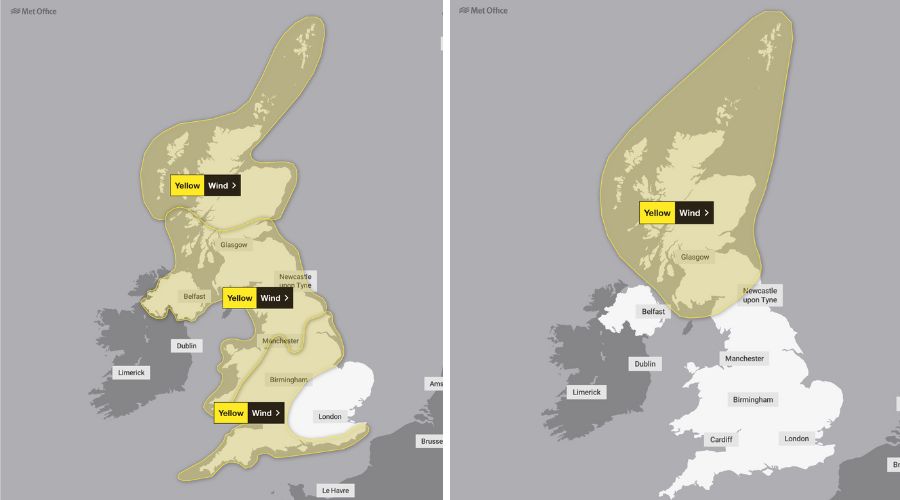
Yellow weather warnings for wind have been issued for much of the country on Friday, and for parts of northern England and Scotland on Saturday, as the UK braces for Storm Éowyn.
It’s the fifth named storm to hit the UK since October.
Who will be affected?
Storm Éowyn could bring gusts in excess of 80mph on exposed coasts in Northern Ireland, northern England, northwestern Wales and western Scotland.
Strengthening winds will initially be seen in southwestern parts of the UK, along with heavy rainfall, the Met Office is forecasting.
This will quickly spread northeast to the rest of the UK during Friday morning.
There is also a chance of snow over Northern Ireland, northern England and Scotland – however much of this will quickly change to rain as milder air moves in.
Stay up to date
Met Office deputy chief meteorologist Mike Silverstone said:
“Storm Éowyn will bring a period of very unsettled, potentially disruptive, weather to the UK through Friday and into Saturday.
“The strongest gusts are likely to be felt across parts of Northern Ireland, northern England, northwestern Wales and western Scotland, where exposed sites could get gusts in excess of 80mph, which has the potential to cause impacts for those in these areas.
“There will also be some heavy rain, bringing some unpleasant conditions to end the week.
“The initial warning for Storm Éowyn has been issued several days in advance, so it’s important to stay up to date with the forecast as further details emerge in the coming days.”
READ MORE: What happens if weather extremes are the new normal?
READ MORE: Norfolk farmer fined for using more water than permitted during drought
READ MORE: Farmers seek financial advice following tough last quarter of 2024
Challenging driving conditions
RAC breakdown spokesperson Alice Simpson warned that driving will be more of a challenge towards the end of this week.
This is especially true for those in the west of England, Scotland and Northern Ireland.
Strong winds mean there’s a higher likelihood of fallen branches and trees on rural routes between motorways and A-roads, which can obstruct journeys and puncture tyres if not carefully avoided.
“Drivers also need to be well aware of the buffeting effect of sudden gusts, especially along coastlines and exposed areas where the worst weather is expected,” she said.
“High-sided vehicles are most at risk of being blown off course, but cars can also be affected as they pass lorries on the motorway and are then hit by the wind on the other side.
“It’s best to keep speeds low and have a firm grip on the wheel to avoid being caught off-guard, especially in areas where heavy rain will affect visibility.”
Looking further ahead
As Storm Éowyn weakens and clears to the northeast of the UK, Saturday will remain a breezy day everywhere with strong winds persisting in the north.
It will be drier for many, with showers replacing persistent heavy rain.
However, later on Sunday, another area of low pressure could bring further wet and very windy weather across the UK, the Met Office concludes.
Advice for farmers
NFU Mutual offers the following advice for storms:
Before the storm
- Stay alert for Met Office weather warnings.
- Regularly inspect your farm and keep on top of maintenance by carrying out necessary repairs to buildings, fences and walls whilst the weather is calm.
- Check that tiles, slates, and roofing sheets are in place and put away any items that cannot be secured.
- Avoid being near barn doors if there are high winds.
- Make sure gutters are not leaking and are clear of leaves and other debris.
- Protect and lag water pipes in vulnerable areas and know where the water supply is so that you can turn it off in the event of burst pipes.
- Ensure you have a good tree inspection programme in place, paying particular attention to trees bordering buildings, roads, railway lines and rights of way.
- Prepare for power cuts: have torches and batteries to hand and make sure any generators are ready to use, and can run at full load for long periods of time, if required.
- Plan evacuation routes to get staff and livestock to safety in the case of extreme weather such as floods – identify higher ground that you can move livestock to in event of flooding.
- Have your insurer’s emergency helpline available. Call NFU Mutual’s 24-hour commercial helpline freephone number on 080028265.
During the storm
- Do not leave the house or make journeys unless absolutely necessary.
- If you need to leave the house, avoid the sheltered side of walls when walking.
- If journeys are essential, drive slowly and carefully, staying aware of high winds on exposed roads and ice and water on the road.
- Do not attempt emergency repairs during the storm.
- Keep all building doors and windows closed.
After the storm
- Be aware after a storm or weather event, power cables or powerlines may have been brought down.
- Don’t enter any buildings that could be unsafe following a storm.
- Report any damage to NFU Mutual as soon as possible.
Read more rural news.

